2023 Site Surveys
Enbridge’s Line 3/93 construction process burst the artesian aquifer in Clearbrook in January 2021 and the company failed to report it to the state. Minnesota’s Attorney General then filed a misdemeanor criminal charge against Enbridge on behalf of Clearwater County (who were unable to manage the case).
The case was continued for dismissal, meaning that:
Enbridge would not have to admit any fault or say they were guilty.
The court would not find Enbridge guilty.
Enbridge’s charges would simply be dismissed if they paid their $1000 fine and then remained “law-abiding” for one year.
Waadookawaad Amikwag summarized some of our damage site data to provide evidence that showed Enbridge had not remained law-abiding. Instead, evidence showed many other places along the Line 3/93 corridor where additional criminal charges might be made. Several Intervenors (parties who want to participate in the legal process as they may be impacted by its outcome) hoped to hold Enbridge accountable for their damages. In late 2023, as Enbridge’s year of required law-abiding was coming to an end, these Intervenors filed a lawsuit asking that these charges not be dismissed and, instead, that further criminal charges be made against Enbridge for additional damage sites that remained unreported.
Minnesota regulators made deals with Enbridge as reported in a 2022 Enforcement Agreement claiming success in securing “$11M in payments, environmental projects, and financial assurances.” This agreement, which also announced the criminal charge against Enbridge, included only three of the aquifer breaches (Clearbrook, LaSalle, MP 1102.5) and all of the frac-out sites. In making this agreement, the state removed possibility for any further financial reimbursement from Enbridge for these damages, even as we understood so little about their impacts. It is unlikely Minnesotans will see a full cost-recovery. More importantly, we cannot restore our lands to what they were before Enbridge installed their pipeline.
At present, work continues in state agencies, a full two years post-construction of the project, with more damages still being discovered and/or reported. Legislators are increasingly pressing for answers on the shortcomings around this process as they hear complaints from their constituents. Meanwhile, the public is getting few details from Enbridge or regulators on the current dangers potentially impacting their groundwater and drinking water. A recent Letter to the Editor at the Bemidji Pioneer considered Enbridge’s Impact to Minnesota Aquifers again asking why their continued failure to admit damages was considered ‘law-abiding’ behavior.
Below are detailed Waadookawaad Amikwag documents showing the damage sites presented as evidence in the Intervention suit.
Note: Some of these damage sites are on public land. Private land sites were accessed with landowner permission and/or with remote sensing tools.
Our surveys describe the damages as the oil flows in Line 3/93. We begin with the Trail-360th and Gully Fen locations and move eastward along the corridor. Our easternmost site is the fourth aquifer breach, which this team brought to public awareness in July 2023 (Moose Lake, Aitkin County). Damage sites along the corridor, both east and west of these reported sites, have been visited. We have data on over 30 places awaiting formal analysis and documentation. As the Waadookawaad Amikwag Field and Science Teams are able to gather and process findings, these additional site surveys will be added here for public use.
Update:
The State of Minnesota dismissed the Enbridge criminal charge on February 5, 2024… without fanfare.
Trail @ 360th Ave NE
This site, on private land, indicates a possible aquifer breach. Located in 1855 Treaty Territory, it is 10.3 miles from Red Lake Reservation. Multiple visits and drone flights have confirmed cold upwelling groundwater, emerging at the pipeline installation.
This site was not included in the 2022 enforcement agreements.

Trail @ Gully Fen
This site, on private land where Line 3/93 crosses a stream turned drainage ditch, indicates a possible aquifer breach. Located in 1855 Treaty Territory, it is 10.9 miles from Red Lake Reservation. Multiple visits and drone flights have confirmed cold upwelling groundwater, emerging at the pipeline in this location. DNR notified WA of this site noting they have directed Enbridge to conduct monitoring.
This site was not included in the 2022 enforcement agreements.

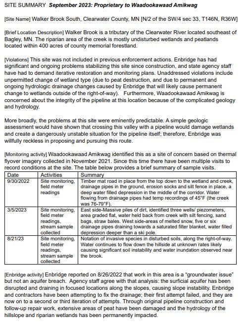
Walker Brook South
This site, within 400 acres of county memorial forest has been confirmed by DNR as an Unconfined Aquifer Breach (an unpressurized aquifer that is open at the ground surface to accept rain and runoff) yet it REMAINS UNDISCLOSED to the public. This site is in 1855 Treaty Territory just 3.4 miles from White Earth Reservation.
One of the most visited damage sites, a mountain of evidence has confirmed damages that appear now to be impossible to remediable.
This site was not included in the 2022 enforcement agreements.
Mississippi River 1st Crossing
This site, on private land abutting county forest to the east, has been confirmed for both frac-outs and a potential aquifer breach. This site, in 1855 Treaty Territory, is 10 miles from the current White Earth Reservation boundary.
WA monitoring appears the only effort to assess ongoing damages as we hear few updates on mitigation or repair efforts on behalf of state agencies or Enbridge, though a monitoring well was installed in 2023 at the drill site for this HDD location.
This damage site appears to have been included in the 2022 enforcement agreements.

LaSalle Valley
One of three initially reported aquifer breaches, this site can never be returned to pre-construction condition. In 1855 Treaty Territory, this site is 12.2 miles from the current White Earth Reservation boundary. The risks were KNOWN, as Barr Engineering warned a 20’ dig limit to avoid “penetrating into the underlying pressurized deposits”, yet Enbridge willfully violated their contractor’s advice, driving steel pilings almost 30’ into the ground, breaching the aquifer.
This site was included in the 2022 enforcement agreements.

Hay Creek
This site, on private land, is a productive manoomin waterway. This site in 1855 Treaty Territory is 7.2 miles from White Earth Reservation. Geological samples (geotechnical borings) revealed risks at this site prior to construction and flyover data shows large volumes of uncontrolled groundwater flow, possibly from previous projects.
This site was not included in the 2022 enforcement agreements.

Spring Branch Creek
This site, also reported to WA by local observers, is on private land, owned by Enbridge and its affiliates, in a narrow steep-sided valley flowing to Roosevelt Lake. This site in 1855 Treaty Territory is 12.3 miles from Leech Lake Reservation. Emergent hillside springs confirm hydrology changes and Enbridge has installed multiple monitoring wells.
This site was not included in the 2022 enforcement agreements.

Moose Lake
This site, on public land, was finally and formally admitted to the public in July 2023 by DNR as a fourth aquifer breach on the project after WA made our findings public. This site, in 1855 Treaty Territory is 43 miles from Fond du Lac Reservation. While Enbridge promised corrective action, DNR had notified WA that it directed only monitoring. We can never know the full extent of the changes resulting from this breach.
This site was not included in the 2022 enforcement agreements.
